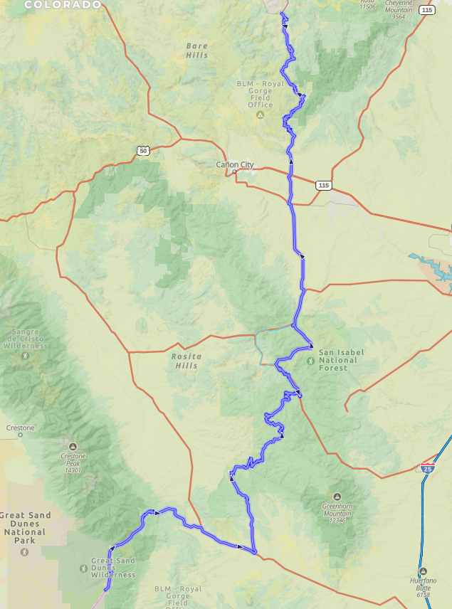
The entire route from Great Sand Dunes National park to Victor, CO is around 130 miles. Once we enter the trail in Great Sandy Dunes, it is around 100 miles before we get to a town with fuel. The city (Florence City, CO) has a single gas station, but we are only 10 miles from Canon City, CO which is much larger with many gas stations and a Walmart and can get any supplies if we need them. Most of the trail is smooth graded road or 2 track, several miles on blacktop, and only the first 20 miles or so are tougher and may affect mileage more. We didn’t haul fuel the last time we went, but everyone needs to make their own judgement call.
Itinerary
Day 1 (7/2/2025)
Destination
Alamosa, CO
Alamosa is just under 500 miles and around 8 hours from Spanish Fork.
Lodging (TBD)
Does anybody have a preference for hotel vs camping for the first night? And if a hotel, any preferences on where they like or hate staying?
Hotels (prices are from google search, and may not be accurate)
Comfort Inn – $119 – pool, breakfast
Quality Inn – $84 – breakfast
Best Western – $111 – pool, breakfast
Fairfield – $144 – pool, breakfast
Days Inn – $80 – Breakfast
Super 8 – $73 – Breakfast, pool
Campgrounds
There are a couple campgrounds near by that have showers, this one in particular has a group site:
Great Dunes Oasis – They have single sites and a group site for 10 or more people, I would need to call to check on openings, no option for that online
Menu
Most meals will likely be on the road, except maybe dinner depending on when we get down to Alamosa.
Day 2 (7/3/2025)
Destination
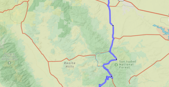
Great Sand Dunes & Enchanted Rockies Trail
Fill fuel tanks in the morning before heading into Great Sand Dunes NP
Before we get to the start of the trail, we can spend some time checking out the dunes, play in the water, etc.
Route Description
The trail starts near the end of the road into the park. In the staging area we will want to air down tires to whatever level you are comfortable with, I can’t remember for sure, but I think we had ours into the mid/upper 20s.
This is a link to a description of the first section of the trail: https://www.nps.gov/grsa/planyourvisit/medano-pass-road.htm
Through most of the initial 20 miles, the trail is pretty narrow, while not difficult at all, it is the toughest section of the entire trail. With as many cars as we have, we will likely want one vehicle a bit further ahead to watch for vehicles coming from the other direction, and give the remaining ones more time to find a place to pull off.
There are also several water crossings, none deep enough to be a problem. When we get to the peak of Medano pass we will hit around 10k feet elevation.
Attractions
The Great Sand dunes are fun to check out. And if you have a sand boogie board, have a run at it!
Lodging
We will be camping on trail. We will have to keep an eye on time and the map, if we get to close to the junction with 69 we will have to get up on the other side a ways above Gardner to get back to winderness and camping spots. From the trailhead to 69 is approximately 21 miles
Menu
Breakfast
Hotel might have breakfast, or we can meet somewhere for breakfast. Ideas?
Lunch
Do we want to arrange lunches as a whole group? Or leave lunches for individual groups?
Dinner
What should we cook or grill? Ideas?
Day 3 (7/4/2025)
Destination
Enchanted Rockies Trail
Route Description
At some point today around 63 miles from the trailhead we will get to Road 165. At this point we will make a detour to the right and check out “Bishop Castle” (See Attactions), Before turning onto Road 165, it would be a good time to air up, we will be on blacktop for approximately 32 miles.
From Bishop Castle we will head back the way we came and continue on road 165, till we get to 67, then take that up to Florence (95 miles from the trailhead) and over to Canon City
While in Canon City we can grab lunch, fill up fuel, purchase groceries/water. And for those that want to check out Royal Gorge (See Attractions)
From there we will head back on trail and into Phantom Canyon to find a place to camp and have dinner for our last night on trail.
Attractions
Bishop Castle
A very interesting and impressive castle built by one man. https://www.bishopcastle.org/
Royal Gorge
There are many activities, scenery, etc. The base admision is $35/person and includes the Bridge, Gondola rides. https://royalgorgebridge.com/
Lodging
We will be camping on trail. Somewhere in Phantom Canyon
Menu
Breakfast
Do we want to arrange breakfasts as a whole group? Or leave breakfasts for individual groups?
Lunch
We will be having lunch in Canon City somewhere
Dinner
What should we cook or grill? Ideas? (We will be picking up the required items in Canon City)
Day 4 (7/5/2025)
Destination
Enchanted Rockies Trail to Victor, CO, then on to Breckenridge, CO
Route Description
Most of the terain is pretty easy, back country two track and graded roads with occasional black top. Once we get to Victor we will air up.
It is around 100 miles and 2 hours from Victor, CO to Breckenridge, CO
Attractions
Victor
The town of victor has various mining equipment to look at.
Breckenridge
The town of Breckenridge has a cute downtown area to check out.
Lodging ( Hotel TBD)
We will be staying in a hotel to be determined. This will be the final night before heading home.
Breckenridge
Quality Inn & Suites Vail Valley – $148 pool, hottub, breakfast
Wingate – $120 – breakfast, and it says pool on google, but not on their site
Hotel Alpenrock by Hilton – $143 – pool, hot tub
Frisco
Comfort Suites Summit County – $125, pool, hot tub
Menu
Breakfast
Do we want to arrange breakfasts as a whole group? Or leave breakfasts for individual groups?
Lunch
Do we want to arrange lunches as a whole group? Or leave lunches for individual groups?
Dinner
We should be in Breckenridge by Dinner time, so most likely something there.
Day 5 (7/6/2025)
Destination
Home!!
It is just over 400 miles and 6.5 hours to Spanish Fork from BreckenRidge
Route Description
I70 West to Highway 6.. Oh, you know the way!! I’m open to caravaning home if others are.
Lodging
Your own bed!!
Menu
Breakfast
Hotel might have breakfast, otherwise we can stop somewhere.
Lunch
Somewhere along the way
Dinner
Could possibly be home by then. If so, anybody want to grill something at Rodegeb house before finishing their trip home?
Notes
Fuel
The entire route from Great Sand Dunes to Victor is around 120 miles. Most of which is on gravel road, two track, and paved roads. Around 100 miles in, we will hit Florence and Canon City with plenty of fuel options. From Victor it is around 100 miles, most of which will be paved, and there are fuel options approximately 20 miles from Victor. Use your own judgement for your vehicle, but you most likely won’t need additional fuel for this trip.
Food & Water
Chatting with Chad – we figured to cut down on what needs to be packed, we can take advantage of Canon City, stock up for dinner that evening, water, eat lunch. So, from the start we would only need around 2.5 gallons of water per car, and either divy it up, or use just a couple larger 5 gallon jugs. And for food, just breakfast, lunch and dinner the first day on trail, and breakfast 2nd day, and breakfast and lunch for 3rd day,
Shared Items
I created a google document for shared items, feel free to update items you are bringing to share, and add items if they aren’t already on the list.
https://docs.google.com/spreadsheets/d/1mxiIhsvIuk2GQ7mgzBy3L_lkcwyv6XYROR5bUGAIabo/edit?usp=sharing
GPS Tracks & Waypoints
Also – If you are using GaiaGPS and want the tracks and waypoints let me know. I have a folder in GaiaGPS that I can share directly I just need the email address you registered with Gaia. Then you will see anything that is added, and have the ability to add to it as well.